2019年7月号 [Vol.30 No.4] 通巻第343号 201907_343003-en
Urban Systems Design Studio: Towards Japanese smart city
The concept of Smart City is often associated with the implementations of advanced technology to enhance the efficiency of resource consumption and operations of an urban area. However, in what way can such an approach contribute toward better well-being, a vibrant local economy, and a sustain and resilience future? Also, how such a concept can be applied to a historical urban neighbourhood, such as Kyojima and North Sumida?
The questions above were among those addressed during the workshop: Tokyo Smart City Studio - Kyojima. The workshop was held between 18th – 23rd March 2019 and organised by the Global Carbon Project-Tsukuba International Office (GCP), a Future Earth project. It was carried out in collaboration with the University of Tokyo, Tokyo Denki University, Georgia Institute of Technology, and Sumida ward.
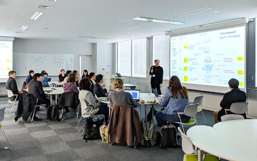
Ass. Prof. Perry Yang presents the workshop briefing to the participants
The objective of the workshop is to develop smart city solutions that can positively revitalise the local economy, stimulate healthy lifestyle, reduce the environmental footprint, and enhance the safety, security, and resilience of the study area. The workshop built on the successes of the two previous studios that took placed in 2017 (Urawa-Misono) and 2018 (also Kyojima). It brought together more than 40 multidisciplinary students and professional researchers in the fields of urban planning, transport planning, and architectures.
Kyojima was selected as the case study for its multifaceted challenges. The historical district survived the 1923 Greet Kanto Earthquake and the firebombing during World War II. Certain characteristics of the area, such as its irregular block shapes, can be traced back to the Edo period. Today, Kyojima is predominantly a dense residential area with multiple narrow streets crisscrossing throughout. A high proportion of this high-density neighbourhood is wooden houses built on alluvial soil, making them prone to fire risk and earthquake. The narrow streets are also barriers to emergency vehicles and means that the firebreaks between buildings are non-existence.
Moreover, it is at or below sea-level and situated in close proximity to the Sumida river, making it highly susceptible to flooding. These natural disaster threats have made Kiyojima a strong concern for the local authority. Several attempts have been made in the past to redevelop the area but were met with strong local resistance. Socially, the area has a high proportion of the ageing population. Yet, it has the potential to attract a younger population with its affordable housing stocks.
The six-day Smart city workshop features a range of activities; from oral presentations, a creative brainstorming session, and seminal discussions. At the beginning of the workshop, representatives from Sumida ward welcomed the participants and provided them with background information of the neighbourhood. They presented the on-going urban development projects in Sumida, such as the road realignment project, which aims to increase the clearance gaps between buildings for safety precaution. The presentation was followed by a lively discussion between the participants and the representatives on the challenges faced by the local authority in ensuring the area’s livelihood and safety. The participants then visited the study area to make on-street observations and collected data. Several novel techniques, such as vitality (heart-rate) and environmental (air pressure, temperature, humidity, and UV) sensors, were used to capture the urban environment conditions. A street-level mapping exercise was also undertaken to record the walkability and streetscape quality of the area using smartphone devices.
Using the data and information collected, the participants of the studio created several concepts and design solutions to address the challenges of Kyojima as summarised in Table 1.
Table 1: A summary of design solutions for Kyojima
| Design solutions | Description |
|---|---|
| Smart mobility |
|
| Experiential Loop + Virtual |
|
| Green Grid (low energy urban-buildings) |
|
| Renewable Community |
|
| Object-oriented Smart Community Planning Support System |
|
The participants of the studio presented their design solutions and the integrated concepts to the representatives from the Sumida ward and the publics who interested on Saturday 23rd March at Tokyo Denki University. The presentation began with remarks from Dr Yoshiki Yamagata, Prof Perry Yang, Prof Akito Murayama, Prof Kanae Matsui. Following key presentation by the studio’s representatives summarising its work, several audience members raised several points regarding the research topics, which can be summarised as follow:
- With the current and projected technological advances, is it necessary to expand existing roadways to accommodate current cars and emergency vehicles? Should current efforts in urban development consider the emerging innovation that can help to address the causes?
- How are these interventions affecting the well-being and health of the locals? In what way can these effects be quantified? Are there solutions in the short or long term to deal with the pressing concerns of ageing communities? Could the smart hubs, autonomous vehicles, or experiential modelling be employed to better the current conditions?
- Ageing communities indicate an ailing community and one way to address this is to induce the attraction of younger populations to strength and engage with the community.
- Plenty of research is being done investigating technologies meant to improve our lives, but at what rate should these technologies be adopted, implemented, or used? Historically single use dedication and adoption of technologies have been met with negative effects, how to combat this?
- How can these research agendas be applied to a grander context, outside of Sumida Ward and Kyojima? As these results while specifically useful are also of interest to neighbouring wards and areas outside of Japan.
- Autonomous Vehicles are playing a larger role in discussions of future cities, how should they be implemented so as not to have negative social effects? For example, deliveries from door to door increase total traffic on the road, logistical routing, and may result in less community interaction. How can these negative outcomes be avoided or mitigated?
The workshop program and presentation slides are available at
http://cger.nies.go.jp/gcp/tokyo-smart-city-studio-2019.html
Peraphan Jittrapirom, Dr. tech.
Peraphan has a background in Civil Engineering and graduated from the University of Bristol, UK. He worked as a highway and traffic engineer consultant in the UK for a period, providing technical support for clients in the public and private sectors. He returned to academic and completed his PhD on Sustainable Transport planning at Vienna University of Technology. While he was In Vienna, he also worked for the Club of Vienna, a think-tank, and Thailand’s permanent mission to the United Nation’s Industrial Development Organisation (UNIDO). He moved to the Netherlands for post-doctoral research at Radboud University, Nijmegen before joining GCP Tsukuba International Office as its research associate and director in May 2019.
His research field is mobility planning, participatory planning, decision and policy making under uncertainty, and planning for Mobility as a Service implementation. He is proficient in transport modelling, system dynamics, and several group facilitation methods. In his free time, he practices Buddhism, playing tennis, making coffee, hiking, and enjoying a good book.
“My interest in transport stems from recognising its ubiquitous in our daily life - Human well-being can be highly affected by the quality of the transport system, which also has wider implications to the environment. I am excited by the opportunity to contribute to the on-going research at GCP on urban planning, mobility design, and carbon management.”