
What is CONTRAIL?
Passenger aircraft based measurements of atmospheric CO2 and other trace gases
Greenhouse gases such as carbon dioxide (CO2) in the atmosphere has been increasing since the beginning of the industrial age. There is now sufficient scientific evidence to show that the observed increases in well-mixed greenhouse gas concentrations since around 1750 are unequivocally caused by human activities (IPCC, 2021). How well we can predict the future states of climate, its change and variability depend greatly therefore on how well we can predict the future levels of CO2 and other greenhouse gases in the atmosphere. The spatial and temporal variations of atmospheric CO2 contain information about the nature and characteristics of the CO2 exchange processes between the atmosphere and the land biosphere and the oceans. However, right now there is an acute shortage of observations of CO2 in the atmosphere to constrain and reduce large uncertainties in the inverse CO2 flux estimates; the severity of this shortage is particularly critical in the portion of the atmosphere above the planetary boundary layer.
Commercial airlines provide a powerful observational platform for obtaining free tropospheric CO2 systematically for long periods of time over a large geographical space. The first phase of the JAL project from 1993 to 2005 was carried out using an automated flask sampling system to obtain a long-term record of CO2 and other trace gases. The CO2 record over the western Pacific has provided valuable information on the latitudinal distribution of the atmospheric CO2 seasonal cycle and on the inter-annual variation of long-term increasing trends in the upper troposphere of both the Northern and Southern Hemispheres (Matsueda et al., 2002).
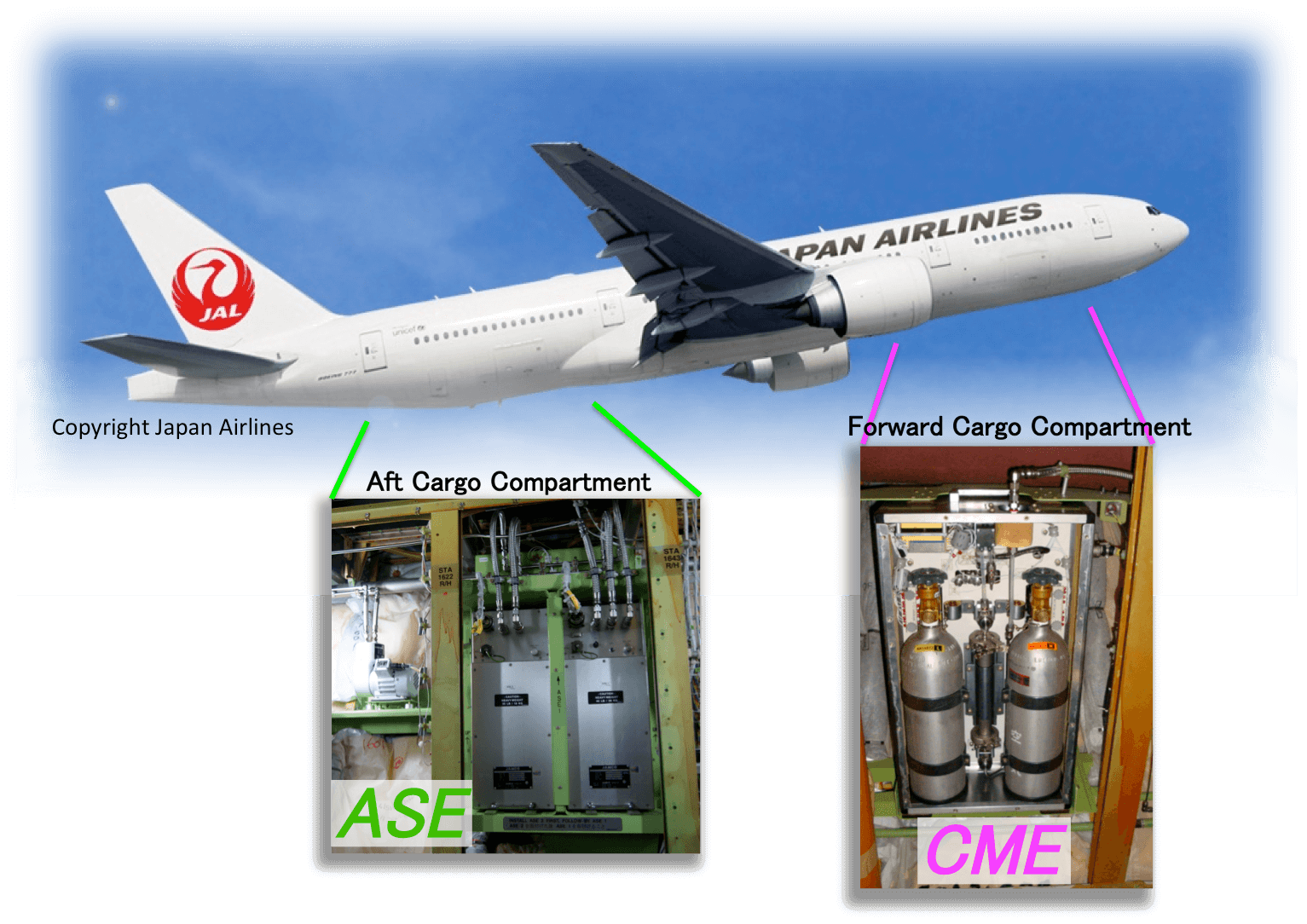
For the second phase of the JAL project (Comprehensive Observation Network for TRace gases by AIrLiner: CONTRAIL), a new Automatic air Sampling Equipment (ASE) for flask sampling and a new Continuous CO2 Measuring Equipment (CME) for in-situ CO2 measurements were installed on Boeing 747-400 and Boeing 777-200ER aircraft in 2005-2006 (Machida et al., 2008; Matsueda et al. 2008). Boeing 777-300ERs were modified to install CME 2015 and 2016. In all, one or both of these instruments have been installed on several Boeing aircraft operated by JAL with regular flights from Japan to Australia, Europe, East, South and Southeast Asia, Hawaii, and North America, providing large spatial data coverage, particularly in the Northern Hemisphere.
References
- IPCC Climate Change 2007: The Physical Science Basis. Contribution of Working Group I to the Fourth Assessment Report of the Intergovernmental Panel on Climate Change (2007), [Solomon, S., D. Qin, M. Manning, Z. Chen,M. Marquis, K.B. Averyt, M. Tignor and H.L. Miller (eds.)], Cambridge University Press, Cambridge, United Kingdom and New York, NY, USA, 996 pp..
- Nakazawa, T., K. Miyashita, S. Aoki, and M. Tanaka (1991), Temporal and spatial variations of upper tropospheric and lower stratospheric carbon dioxide, Tellus, Ser. B., 43, 106-117.
- Machida, T., H. Matsueda, Y. Sawa, Y. Nakagawa, K. Hirotani, N. Kondo, K. Goto, N. Nakazawa, K. Ishikawa and T.Ogawa (2008), Worldwide measurements of atmospheric CO2 and other trace gas species using commercial airlines, J. Atmos. Oceanic Technol., 25(10), 1744-1754, doi:10.1175/2008JTECHA1082.1.
- Matsueda, H., H. Y. Inoue, and M. Ishii (2002), Aircraft observation of carbon dioxide at 8-13 km altitude over the western Pacific from 1993 to 1999, Tellus, Ser. B, 54, 1-21.
- Matsueda, H., T. Machida, Y. Sawa, Y. Nakagawa, K. Hirotani, H. Ikeda, N. Kondo, and K. Goto (2008), Evaluation of atmospheric CO2 measurements from new flask air sampling of JAL airliner observations, Pap. Meteorolo. Geophys., 59, 1-17.
