MAKSYUTOV, S., ODA, T., SAITO, M., TAKAGI, H., BELIKOV, D., VALSALA, V.
CGER Reports
CGER’s Supercomputer Monograph Report Vol. 25
Summary
Inverse modeling of the surface greenhouse gas fluxes is a widely used method to estimate the regional sources and sinks based on matching the observed atmospheric concentrations with atmospheric transport model simulation. In 2009, the global greenhouse gas observing system was enhanced by putting on orbit a Japanese Greenhouse Gas Observing SATellite (GOSAT), which provided significant improvement in accuracy over other satellites, and created many new opportunities for observing global carbon and methane cycles. Accurate simulation of the stratospheric CO2 and methane profiles is required for matching with GOSAT total column measurements. For operational processing, there is a need to update regularly the surface flux datasets, meteorological reanalysis data. Ability of GOSAT to observe not only clean, background air, but also air influenced by man-made, anthropogenic emissions, open opportunities for monitoring the emissions and their trends. That objective demands development of the new high resolution atmospheric transport models and inverse modeling techniques. In this monograph, we report development of the models and inventories for GOSAT data analysis and applications, including the atmospheric transport model, high resolution carbon dioxide emission inventory, the inverse model for GOSAT Level 4 product and high resolution transport model.
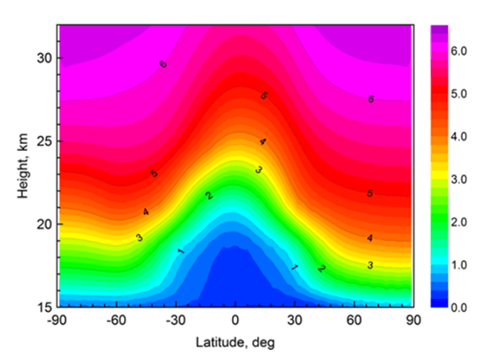
Chapter 1 introduces development of an improved version of the National Institute for Environmental Studies (NIES) three-dimensional chemical transport model (TM) designed for accurate tracer transport simulations in the stratosphere, using a hybrid sigma–isentropic (σ–θ) vertical coordinate. Multi-annual simulations were conducted using the NIES TM to evaluate vertical profiles of CO2, CH4 and SF6 by comparisons with balloon-borne observations over Sanriku (Japan).

Chapter 2 describes a gridded inventory of the fossil fuel emissions capable of high resolution and global coverage and available with annual updates. In the Open-source Data Inventory for Anthropogenic CO2 (ODIAC) the emission spatial distributions are estimated at a 1 × 1 km resolution using power plant data (emission intensity and geographical location) and satellite-observed nighttime lights.

Chapter 3 introduces the GOSAT Level 4 CO2 product algorithm – estimating regional CO2 fluxes using GOSAT and surface observations of atmospheric CO2. The forward modeling components of the system include an atmospheric tracer transport model (presented in Chapter 1), an anthropogenic emissions inventory (presented in Chapter 2), a terrestrial biosphere exchange model, and an oceanic flux model. Monthly CO2 fluxes of 64 sub-continental regions, were estimated from the GOSAT FTS SWIR Level 2 XCO2 retrievals (ver. 02) gridded to 5° × 5° cells and averaged on a monthly basis and monthly-mean GLOBALVIEW-CO2 data.

Chapter 4 introduces a further development of a coupled Eulerian-Lagrangian transport model, suitable for estimating the anthropogenic emissions with ground-based and satellite data due to high resolution capability. The forward tangent linear and adjoint components of the Eulerian model were constructed from the NIES TM code. The developed adjoint of the coupled model combines the flux conservation and stability of an Eulerian discrete adjoint formulation with the flexibility, accuracy, and high resolution of a Lagrangian backward trajectory formulation.


 PDF, 6.2 MB